Showing posts with label Hiking. Show all posts

Sunday, February 16, 2014

Yunnan Part 5: Upper and Lower YuPeng

A view from our window in Upper YuPeng, Meili Xueshan National Park, Yunnan, China

Ahhh .... the best part of Meili XueShan National Park... Yupeng (pronounced we-pong). We still, 4 months later, talk about this place nostalgically... Nestled in a valley just before the great snowy mountains lies this little Tibetan town. Two little Tibetan towns to be exact. It's kind of like stepping back in time to some mythical village. No car roads lead here so anything that is here is brought in by donkey. Apparently they have only had electricity here for a year or two.

Ok, let's be clear about one thing, though. While these towns may have always been here in some shape or form, these two towns have certainly grown substantially with tourism. Houses here have clearly been built with the idea that they would be guesthouses. But don't let that turn you away, most residents that we met come from just on the other side of the mountain in Ninong (I'll get to there in another post) and as you can see in the photo above, all the buildings have been built in the typical Tibetan style. Thanks to the money from tourism, the locals can actually afford to do that. Here in India where I am now, while there are hundreds of Tibetans living around me, it's nearly impossible to find houses built in this style, probably due to lack of funds and lack of experience in building these homes.

Building a new, traditional style Tibetan house. 

But life here in Yupeng is good. Though it is located some 2,500m above sea level, its location so near the tropics (just a hop, skip and a jump from the border of Myanmar and about a day or two drive from Vietnam) so there is never any snow.

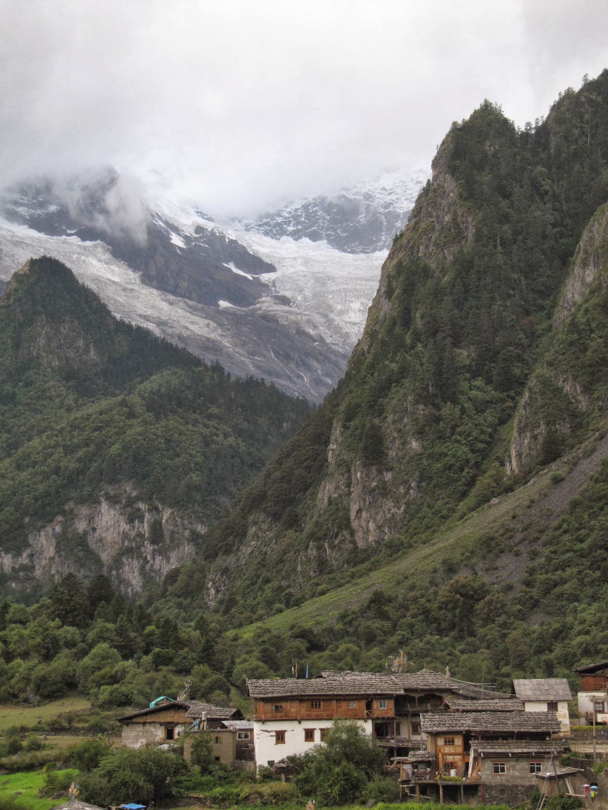
View of the glacier from Upper YuPeng

The view from our bedroom window in Upper YuPeng afforded us a beautiful (though often covered by clouds) view of the glacier in the mountains nearby...

Cooking dinner in Upper YuPeng

Cooking out here is done the old fashioned way, on a wood stove. It was fascinating to watch this woman, who was our guesthouse owner, run the kitchen.

Dinner in Upper YuPeng

Food here was mainly Chinese style. We kept asking around for Tibetan food, but everyone looked at us a little strangely and couldn't understand why we would ask for such a strange thing. So, we mostly ate lots of fried vegetables and rice. Fortunately we like fried vegetables and rice.

Maybe breakfast? in Upper YuPeng
 
Preserved meat in Upper YuPeng

With no car access, anything eaten here must either be grown here or lugged in on a mule or backpack. Meat, of course, could not be sealed and stored in refrigerators as it would be in developed places so meat was salted and preserved and kept on the wall, as you can see above. I'm sure the salting process is not too unlike that which Americans used many years ago. When we ordered food with meat in it, she would just take down this salted pork from the wall and shave off a few small slices and add it to the food.

Dali Beer

We did enjoy a number of these 大理啤酒 (Dali Beer) on our trip, it seems to be one of the only beers available in many rural areas of Yunnan Province. However the beer is quite weak, just 2.5% alcohol... But, I suppose we should not have been drinking it at all as it had to be carried in by mule and hopefully the used bottles were also being lugged out by mule. The price was several yuen more than what it cost in restaurants in the city.

Drinking with the locals

Another exciting moment for us with the local cuisine was sampling the local liquor. We had chatted with this woman, the one with the black vest in the center of the photo, earlier in the day and she told us that she makes her own, homemade, liquor. We told her we wanted to try it later, so around 8pm that night we headed down to her restaurant in the dark and inquired if she were open. Of course we were the only ones in the deserted restaurant but she was excited to show us her liquor and we were excited to try it. We wanted to try both her wine and her barley liquor, so we ordered one of each. However, it was far too much alcohol to drink for the two of us (you can see the containers, the barley liquor was probably 40-50% alcohol...). So, we started recruiting locals to drink with us. Once the woman sitting next to me wondered in, completely drunk, it wasn't hard to get the rest of our drinks drunk as she was more than willing to help, plus getting others to join her in her drunkenness.

Mules in front of traditional Tibetan house in Upper YuPeng

Life in YuPeng runs at a slow pace. There are animals roaming the streets in all directions. While a lot of the local economy is now supported by tourism, it still logistically makes sense to keep up the agricultural way of life as everything here still needs to be brought in by horse if it's not made here.

Pigs

Calf

 Pet monkey?

Not sure what's up with the pet monkey, but it was a little scary and tried to attack us... I think...

Our accommodations in Upper YuPeng

Accommodations here were rustic and simple, as one would expect when trekking I suppose. But, we thought this place was quite nice and clean for $3 USD/ person/ night (20 yuen per night). Not really what most people imagine when they think about honeymoons... but, it was a different kind of romantic I suppose...

Our lovely hosts in Upper YuPeng

After two nights in upper YuPeng we sadly left our guest house and said good bye to those working there and headed down to lower YuPeng for the next night. Lower YuPeng seems to be a more popular place to stay because it has a slightly better view of the Meili Xueshan mountain. However, considering the fact that the mountain is nearly always covered in clouds, or at least it was when we were there, we found life in upper YuPeng much more enjoyable. Fewer tourists, friendlier people, and cheaper accommodations. We went around to several guesthouses before we were able to find one that was both cheap and had a good view. But we paid for it with bedbugs...

Our accommodations in Lower YuPeng

Temple in lower YuPeng

View of the mountains from Lower YuPeng

A moment of clear skies in Lower YuPeng. 

Overall, both Upper and Lower YuPeng are beautiful, fantastic places which have been relatively untouched by modernity. They are fantastic places to find traditional architecture, good meals made with fresh ingredients, kind people, and fantastic views. The husband and I, even now 5 months later long to return to YuPeng...

Sunday, January 19, 2014

Yunnan Part 4: BingHu (Glacial Lake)- Meili Xueshan National Park


The road to Bing Hu

While most trekkers try hard to get out early in the morning in order to maximize their days, we were kind of lazy trekkers... we'll say our excuse was our honeymoon, but it is entirely possible that we are just extremely lazy trekkers in general. Nevertheless, we finally got our gears in motion, probably close to noon on our second day in Meili Xueshan National Park. We asked around to the locals how long it would take to get up to BingHu 冰湖 (the glacial lake or literally 'Ice Lake'), and we were told 2-3 hours there and back. That sounded quite reasonable to us, so we headed out of town towards the lake.


We got a little lost once or twice, but eventually we found ourselves on the correct path to the lake. It was rainy, and we were very thankful that we had both bought ourselves quick drying hiking pants before coming on this trip...


After two hours of hiking up (and no sign of any other hikers) we started to wonder if we really were on the right path... Finally, we met one person coming down and they informed us that we should expect to arrive within an hour to 1.5 hours. Hm... not quite 2-3 hours there and back as we were originally told.... 


Finally, after three hours of hiking we were finally within sight of the end. We could see the glacier now, and we just had to climb up one more small peak to reach it...


Utterly exhausted we finally made it to the top of the peak and looked down at the glacial lake. While it was a lot smaller than I expected, I would recognize that blue color anywhere from the last time I was near a glacier, way back in 2006 in Patagonia. If only I had been blogging at that time...


Some people ventured down to the water's edge for photos, but we were exhausted, it was getting late and we still had to go all the way back the way we came.


There's not enough houses up here to call it a village, but there seem to be a few people who live way up here in the mountains... and their cows roam freely around the open grassy area near the river flowing from the glacial lake...


Walking back we found a slightly different route that was a little more scenic. Here is another Tibetan prayer wheel, this time it spins with the flow of the water, I guess it's like putting the mantra inside on repeat keeping the world saved from evil... or something like that.

Finally we got back to YuPeng for another night in our guesthouse. We certainly slept well that night... We also learned our lesson. When Tibetans tell you how long it will take to walk/hike from one place to another... double the the time they tell you....

Saturday, January 18, 2014

Yunnan Part 3: Feilaisi to Upper Yupeng - Meili Xueshan National Park


The next morning, we woke up and decided to make our decent into Xidang, the starting off point of hiking trails in Meili Xueshan National Park. Before leaving Feilaisi, we got some breakfast of dumplings and Tibetan butter tea. I was very excited about drinking this tea, as it is a staple in the Tibetan diet. I was a little disappointed by the taste. It is very strong.. it tastes... just about how you would expect butter tea to taste. Not great. But, I forced myself to drink it down and head out for the National Park.

From there, we had to find a minivan (called Baoche 包车)to take us down to Xidang. We thought we would have to hire one on our own, as we got  a later start than most hikers in the area, but then we bumped into a group of five Chinese tourists who also were heading to the same place and we were able to share the minivan with them.


In order to enter the national park, you need to have a ticket like this. Actually, the price is quite high, but it includes entry into the park, Feilaisi, YuPeng, and another location we never found. You can buy this ticket either at the gate to the park or near Feilaisi and the cost is 230 Yuen ($38). Considering that once you are in the park, you can eat and sleep for $5-10 USD/ day per person, it's worth spending the money.


Finally we arrived in Xidang and were brought to the starting point of the hiking area. In order to go further into the National Park, one must go either on foot or by mule as there are no roads that lead in to the towns deep in the mountains. We didn't stop to rest here but made our way straight to the trail and started our upward climb. 


About an hour or two into our climb we happened upon our first rest stop. Here you could buy all manner of things, the most popular being a Chinese form of Red Bull (see the yellow cans piled high), Snikers, Dove Bars, and ramen.


We wanted the local cuisine, however and opted for more butter tea and some sort of fried bread.  Then we continued on our hike up the mountain. 


About four hours or so into our hike, we made it to our next rest stop and got ourselves some lunch. Here, the most popular fare was by far the ramen, so we figured there was no point in being different and bought two cups of ramen noodles. Just to prove the popularity of the ramen here, if you see in the background of the photo above, there are towers of something red in the background. It's hard to tell in the photo, however those are actually piles and piles and piles of used ramen cups. As it can be difficult to dispose of waste up here, the locals have started using the waste as decoration rather than tossing it into the environment around them. Unfortunately, the hoards of Chinese tourists continue to treat the mountain like their own trash barrel and there is trash strewn everywhere, undoubtedly 98% of which comes from tourists (of which probably another 98% happen to be Chinese).


After another hour or so of hiking, we finally reached the top of the mountain, a holy place for the local Tibetan population. While I expected the summit to be a little more exciting, with breathtaking views, those were to come later on the decent on the other side. For now, we had to be satisfied by the prayer flags which covered the summit. 


As I said, the real views were for the hike down the other side, once we reached the inner side of the mountain. The whole hike down afforded us views like this with the snow capped mountains and glacier looming in the distance. 


It was also not uncommon to find collections of objects like this concentrated in one area. I'm not sure yet about the significance here, but I imagine it would be akin to the prayer flags. A way to make a prayer in a holy place. 


Finally, after six hours or so of hiking up and down a large mountain at a relatively high elevation (I think it was 3600 at the peak, but I could be wrong), we finally caught sight of Upper Yu Peng 雨崩村. I can't say I wasn't excited to be done with the hiking (especially with my huge backpack!). We settled down here in Upper Yu Peng for the next two nights to continue our exploration of Meili Xueshan National Park. More on that later.

Monday, May 13, 2013

A hike to Sujong Temple 수종사


Since Buddha's Birthday is just around the corner, on May 17th, we thought it would only be fitting to take a trip up to Sujong Temple/ 수종사. We've been wanting to go here for a while. We see it every time we drive home from Yangsuri, as it's sitting high up on the side of 운길산 (Ungilsan mountain) overlooking the junction of the north and south Han rivers.


To get up to the top, there are several options. There is a road, and many chose to drive up, however hiking may be more rewarding. Small hiking paths zig-zag all over the mountain and they often cross back to the road. We hiked up a combination of both road and hiking paths.


Finally, after about 45 minutes of hiking, we caught our first glimpse of the temple from afar.


Another 10 minutes of hiking up we finally got to the temple. As with most temples at this time of year, the path was decorated with lanterns for Buddha's Birthday.


The temple is most renown for it's view looking over Yangsuri, however with the hazy skies yesterday it was hard to make out much below.


However, despite being famous for the view, it also has an impressive legend to go along with it as well. In 1458, King Sejo was passing through Yangsuri and stayed there overnight. During the night, he heard the sound of a bell, but upon asking the villagers in the morning where the bell sound came from they said it could not have come from the village. Perhaps, though, it could have come from an abandoned temple on Ungilsan, they told him. He sent his men to investigate and they came across a cave filled with Buddhist sculptures... and water dropping that made a bell-like sound. After this, the temple was born with the name 수종사 (水鐘寺) or 'Water Bell Temple'. 

 水- 수/Su/Water
 鐘- 종/Jong/Bell 
寺- 사/Sa/ Temple


It's quite easy to get here from Seoul. Take the Jungang Line to Ungilsan station (50 mins from Wangsimni Station). Come out of exit 1, turn left and take the first street to the right. Follow the street and you will eventually come to signs pointing to the hiking trails to the temple. It's approximately 1 hour hiking to the temple and you can walk up the road or the hiking trails, whichever is more comfortable for you.

Wednesday, June 20, 2012

A hike on the 둘레길 around Bukhansan

 둘레길, Doolegil Trail Marker

A few weeks ago we took a little hike on the 둘레길 (Doolegil), a mountain path that goes around Bukhansan rather than up it. This path fully opened just two years ago and there is still a big loop that has yet to be completed, but as it stands now you can walk around the entire periphery of the mountain. Part of the course is in the wooded area, but there are parts that come out into the city, and that's where it can get a little confusing following the trail. Fortunately there are lines on the ground and many markers everywhere to keep you on course.

Exercise area along the trail

We started in Suyu, following the path north. My friend, who has done other sections of the Doolegil has told me that this was actually one of the least scenic routes, but I still saw plenty and got some good exercise in, so I was happy.

Slight hill along the trail. Trees are wrapped to protect them from insects who would kill them.


Information center near Suyu

There are several information centers along the way where you can pick up maps for Bukhansan which show all the main trails through the mountain, plus the doolegil. While we stopped here, they were filming what seemed to be a promotional video. They couldn't help but interview us 외국인 for their film, telling us about the wonders of Bukhansan. Keep a look out for a tall bald man next time you watch a Korean National Parks video, it could be my friend!

Grave of 광복군

Along the way we saw a sign for the graves of some soldiers of WWII, so we wandered down the path to check them out.

City Farming

Along the path you can see many small farms where locals grow food, presumably to sell in markets as they seem too big to be growing for only personal use. It's hard to believe that there could be gardens like this in the middle of Seoul, but here it is, and we probably passed at least 10 like this one  or bigger along our 4 hour hike.

Jongmu Temple

We also passed a number of temples along the way. This one was the first one, called 종무사, Jongmu Temple. We couldn't tell how to get in, though, so we continued on our way.

4.19 Memorial Cemetery from Above

Next, along the way we found the 4.19 Memorial Cemetery. I had never heard of this place, but after looking it up, it is the resting place for the 224 pro-democracy protesters killed on April 19th, 1960. They were shot in a protest against the president Syng-Man Rhee who rigged the election to secure his second term in office. While we couldn't reach the cemetery from the path, it made me want to check out this place another time as it has a museum attached to it as well.

Lunch

At some point along the way we pulled out our lunch of kimbap. While kimbap is not my favorite food (always forget to tell them to take out the radish), it does make for perfect hiking food as it's cheap, light and easy to pack. And at 1,500 each, how can you find anything better?

Information Center in Ui

This was the second information center we passed in 우이. I like the name of this place because the romanization of it's name is awesome: Ui.  It's a good place to stock up on water at the vending machine or use the toilet as they are rather hard to come by along certain parts of the trail.

Oriental Dollarbird

One member of our group turned out to be quite the bird watcher and, while we didn't have any binoculars, we did have my 48x zoom which spotted this bird which we were able to identify as a Dollarbird. Good name for a bird.

Hwagyesa

After about 4 hours of hiking (with many, many breaks) we decided to call it a day and turn back. We headed back to Suyu by bus and I decided to check out 화계사 Hwagye Temple before heading home. This is also on the Doolegil, but just slightly south of where we started. It's a nice little temple and it was clearly decorated with some of the lanterns left over from the Lotus Lantern Parade a week or two earlier.


Tying a wish to the rope to make it come true!

A hike on the 둘레길 might just be the solution to what ales you. Whether you are looking for exercise, excitement, nature or escape, it's the perfect solution. It's not strenuous because it goes around, not up the mountain, so if you're not big on the whole hiking thing, it could be a good happy medium of getting outside without sweating too much. And for those of you who do like hiking, that's not to say that this trail is completely flat, it's a lot of up and down, but you'll never hike uphill for more than 5 minutes or so before coming down again.

To hike the Doolegil, there are many places to start and it would probably be impossible to do the whole thing in one day unless you are some kind of hiking machine. This is the best map I've found, if you don't understand the Korean, ask a friend to show you the closest starting point to where you live.  I started in Suyu. If you want to start at Hwagye Temple, get off at Suyu Station (Line 4) exit 5. Walk straight to the intersection and turn left. Turn right at the SK gas station up ahead. Follow the road straight for about 10 minutes and you will see the temple gates. The 둘레길 passes right through the temple. My friend recommends going south for a much more scenic view, but I went north from here.